| preceded by | |
|
|||||||||
|
|
|||||||||
| succeeded by |
")
")
")


| Alsacefrom the Wikipedia | Read original article |
| Alsace | ||||||||||
|---|---|---|---|---|---|---|---|---|---|---|
| Region of France | ||||||||||
Cernay and the plain of Alsace;
Strasbourg;
Colmar; Castle of
Haut-Koenigsbourg;
Riquewihr;
Northern Vosges Regional Nature Park;
Mulhouse;
Neuf-Brisach
|
||||||||||
|
||||||||||
 |
||||||||||
| Country | ||||||||||
| Prefecture | Strasbourg | |||||||||
| Departments | ||||||||||
| Government | ||||||||||
| • President | Philippe Richert (2010–) (UMP) | |||||||||
| Area | ||||||||||
| • Total | 8,280.20 km2 (3,197.00 sq mi) | |||||||||
| Population (2006)[1] | ||||||||||
| • Total | 1,815,488 | |||||||||
| • Density | 220/km2 (570/sq mi) | |||||||||
| Demonym | Alsatian | |||||||||
| Time zone | CET (UTC+1) | |||||||||
| • Summer (DST) | CEST (UTC+2) | |||||||||
| ISO 3166 code | FR-A | |||||||||
| GDP (2012)[2] | Ranked 12th | |||||||||
| Total | €53.6 billion (US$69.0 bn) | |||||||||
| Per capita | €28,849 (US$37,105) | |||||||||
| NUTS Region | FR4 | |||||||||
| Website | www.region.alsace | |||||||||


.JPG)


Alsace (French: Alsace [al.zas] (![]() listen); Alsatian: ’s Elsass [ˈɛlsɑs]; German: Elsass, pre-1996 also: Elsaß [ˈɛlzas] (
listen); Alsatian: ’s Elsass [ˈɛlsɑs]; German: Elsass, pre-1996 also: Elsaß [ˈɛlzas] (![]() listen); Latin: Alsatia) is the fifth-smallest of the 27 regions of France in land area (8,280.2 km2), and the smallest in metropolitan France. It is also the seventh-most densely populated region in France and third most densely populated region in metropolitan France, with ca. 224 inhabitants per km2 (total population in 2006: 1,815,488; 1 January 2011 estimate: 1,852,325).
listen); Latin: Alsatia) is the fifth-smallest of the 27 regions of France in land area (8,280.2 km2), and the smallest in metropolitan France. It is also the seventh-most densely populated region in France and third most densely populated region in metropolitan France, with ca. 224 inhabitants per km2 (total population in 2006: 1,815,488; 1 January 2011 estimate: 1,852,325).
Alsace is located on France's eastern border and on the west bank of the upper Rhine adjacent to Germany and Switzerland. The political status of Alsace has been heavily influenced by historical decisions, wars, and strategic politics. The political, economic and cultural capital as well as largest city of Alsace is Strasbourg. The city is the seat of dozens of international organizations and bodies.
The historical language of Alsace is Alsatian, a Germanic (mainly Alemannic) dialect also spoken in part of Lorraine and across the Rhine, but today most Alsatians primarily speak French, the official language of France. 43% of the adult population, and 3% of those 3–17 years old, stated in 2012 that they speak Alsatian.[3][4] The place names used in this article are in French; for the German place names, see German place names (Alsace).
Contents
Etymology[edit]
The name "Alsace" can be traced to the Old High German Ali-saz or Elisaz, meaning "foreign domain".[5] An alternative explanation is from a Germanic Ell-sass, meaning "seated on the Ill",[6] a river in Alsace.
Alsace-Lorraine[edit]
The region, as part of Lorraine, was part of the Holy Roman Empire, and then was gradually annexed by France in the 17th century, and formalized as one of the provinces of France. The Calvinist manufacturing republic of Mulhouse, known as Stadtrepublik Mülhausen, become a part of Alsace after a vote by its citizens on 4 January 1798. Alsace is frequently mentioned with and as part of Lorraine and the former duchy of Lorraine, since it was a vital part of the duchy, and later because German possession as the imperial province (Alsace-Lorraine, 1871–1918) was contested in the 19th and 20th centuries; France and Germany exchanged control of parts of Lorraine (including Alsace) four times in 75 years.
History[edit]
In prehistoric times, Alsace was inhabited by nomadic hunters.
Celtic/Gallic/Germanic Alsace[edit]
By 1500 BC,[citation needed] Celts began to settle in Alsace, clearing and cultivating the land.
Roman Alsace[edit]
By 58 BC, the Romans had invaded and established Alsace as a center of viticulture. To protect this highly valued industry, the Romans built fortifications and military camps that evolved into various communities which have been inhabited continuously to the present day. While part of the Roman Empire, Alsace was part of Germania Superior.
Frankish Alsace[edit]
With the decline of the Roman Empire, Alsace became the territory of the Germanic Alemanni. The Alemanni were agricultural people, and their language formed the basis of modern-day dialects spoken along the Upper Rhine (Alsatian, Alemannian, Swabian, Swiss). Clovis and the Franks defeated the Alemanni during the 5th century AD, culminating with the Battle of Tolbiac, and Alsace became part of the Kingdom of Austrasia. Under Clovis' Merovingian successors the inhabitants were Christianized. Alsace remained under Frankish control until the Frankish realm, following the Oaths of Strasbourg of 842, was formally dissolved in 843 at the Treaty of Verdun; the grandsons of Charlemagne divided the realm into three parts. Alsace formed part of the Middle Francia, which was ruled by the youngest grandson Lothar I. Lothar died early in 855 and his realm was divided into three parts. The part known as Lotharingia, or Lorraine, was given to Lothar's son. The rest was shared between Lothar's brothers Charles the Bald (ruler of the West Frankish realm) and Louis the German (ruler of the East Frankish realm). The Kingdom of Lotharingia was short-lived, however, becoming the stem duchy of Lorraine in Eastern Francia after the Treaty of Ribemont in 880. Alsace was united with the other Alemanni east of the Rhine into the stem duchy of Swabia.
Alsace within the Holy Roman Empire[edit]
At about this time the surrounding areas experienced recurring fragmentation and reincorporations among a number of feudal secular and ecclesiastical lordships, a common process in the Holy Roman Empire. Alsace experienced great prosperity during the 12th and 13th centuries under Hohenstaufen emperors. Frederick I set up Alsace as a province (a procuratio, not a provincia) to be ruled by ministeriales, a non-noble class of civil servants. The idea was that such men would be more tractable and less likely to alienate the fief from the crown out of their own greed. The province had a single provincial court (Landgericht) and a central administration with its seat at Hagenau. Frederick II designated the Bishop of Strasbourg to administer Alsace, but the authority of the bishop was challenged by Count Rudolph of Habsburg, who received his rights from Frederick II's son Conrad IV. Strasbourg began to grow to become the most populous and commercially important town in the region. In 1262, after a long struggle with the ruling bishops, its citizens gained the status of free imperial city. A stop on the Paris-Vienna-Orient trade route, as well as a port on the Rhine route linking southern Germany and Switzerland to the Netherlands, England and Scandinavia, it became the political and economic center of the region. Cities such as Colmar and Hagenau also began to grow in economic importance and gained a kind of autonomy within the "Decapole" or "Dekapolis", a federation of ten free towns.
As in much of Europe, the prosperity of Alsace came to an end in the 14th century by a series of harsh winters, bad harvests, and the Black Death. These hardships were blamed on Jews, leading to the pogroms of 1336 and 1339. In 1349, Jews of Alsace were accused of poisoning the wells with plague, leading to the massacre of thousands of Jews during the Strasbourg pogrom.[7] Jews were subsequently forbidden to settle in the town. An additional natural disaster was the Rhine rift earthquake of 1356, one of Europe's worst which made ruins of Basel. Prosperity returned to Alsace under Habsburg administration during the Renaissance.

German central power had begun to decline following years of imperial adventures in Italian lands, ceding hegemony in Europe to France, which had long since centralized power. France began an aggressive policy of expanding eastward, first to the Rhône and Meuse Rivers, and when those borders were reached, aiming for the Rhine. In 1299, the French proposed a marriage alliance between Philip IV of France's sister Blanche and Albert I of Germany's son Rudolf, with Alsace to be the dowry; however, the deal never came off. In 1307, the town of Belfort was first chartered by the Counts of Montbéliard. During the next century, France was to be militarily shattered by the Hundred Years' War, which prevented for a time any further tendencies in this direction. After the conclusion of the war, France was again free to pursue its desire to reach the Rhine and in 1444 a French army appeared in Lorraine and Alsace. It took up winter quarters, demanded the submission of Metz and Strasbourg and launched an attack on Basel.
In 1469, following the Treaty of St. Omer, Upper Alsace was sold by Archduke Sigismund of Austria to Charles the Bold, Duke of Burgundy. Although Charles was the nominal landlord, taxes were paid to Frederick III, Holy Roman Emperor. The latter was able to use this tax and a dynastic marriage to his advantage to gain back full control of Upper Alsace (apart from the free towns, but including Belfort) in 1477 when it became part of the demesne of the Habsburg family, who were also rulers of the empire. The town of Mulhouse joined the Swiss Confederation in 1515, where it was to remain until 1798.
By the time of the Protestant Reformation in the 16th century, Strasbourg was a prosperous community, and its inhabitants accepted Protestantism in 1523. Martin Bucer was a prominent Protestant reformer in the region. His efforts were countered by the Roman Catholic Habsburgs who tried to eradicate heresy in Upper Alsace. As a result, Alsace was transformed into a mosaic of Catholic and Protestant territories. On the other hand, Mömpelgard (Montbéliard) to the southwest of Alsace, belonging to the Counts of Württemberg since 1397, remained a Protestant enclave in France until 1793.
Incorporation into France[edit]
This situation prevailed until 1639, when most of Alsace was conquered by France so as to keep it out of the hands of the Spanish Habsburgs, who wanted a clear road to their valuable and rebellious possessions in the Spanish Netherlands. The French in the context of the Thirty Years' War (1618–48). Beset by enemies and seeking to gain a free hand in Hungary, the Habsburgs sold their Sundgau territory (mostly in Upper Alsace) to France in 1646, which had occupied it, for the sum of 1.2 million Thalers. When hostilities were concluded in 1648 with the Treaty of Westphalia, most of Alsace was recognized as part of France, although some towns remained independent. The treaty stipulations regarding Alsace were complex; although the French king gained sovereignty, existing rights and customs of the inhabitants were largely preserved. France continued to maintain it customs boundary along the Vosges mountains where it had been, leaving Alsace more economically oriented to neighbouring German-speaking lands. The German language remained in use in local administration, in schools, and at the (Lutheran) University of Strasbourg, which continued to draw students from other German-speaking lands. The 1685 Edict of Fontainebleau, by which the French king ordered the suppression of French Protestantism, was not applied in Alsace. France did endeavour to promote Catholicism; Strasbourg Cathedral, for example, which had been Lutheran from 1524 to 1681, was returned to the Catholic Church. However, compared to the rest of France, Alsace enjoyed a climate of religious tolerance.
The warfare that had partially depopulated the region created opportunities for a stream of immigrants from Switzerland, Germany, Austria, Lorraine, Savoy and other lands that continued until the mid-18th century.[citation needed] Between 1671 and 1711 Anabaptist refugees came from Switzerland, notably from Bern.[citation needed] Strasbourg became a main centre of the early Anabaptist movement.[citation needed]

France consolidated its hold with the 1679 Treaties of Nijmegen, which brought most remaining towns under its control. France seized Strasbourg in 1681 in an unprovoked action. These territorial changes were recognised in the 1697 Treaty of Ryswick that ended the War of the Grand Alliance.
French Revolution[edit]

The year 1789 brought the French Revolution and with it the first division of Alsace into the départements of Haut- and Bas-Rhin. Alsatians played an active role in the French Revolution. On 21 July 1789, after receiving news of the Storming of the Bastille in Paris, a crowd of people stormed the Strasbourg city hall, forcing the city administrators to flee and putting symbolically an end to the feudal system in Alsace. In 1792, Rouget de Lisle composed in Strasbourg the Revolutionary marching song "La Marseillaise" (as Marching song for the Army of the Rhine), which later became the anthem of France. "La Marseillaise" was played for the first time in April of that year in front of the mayor of Strasbourg Philippe-Frédéric de Dietrich. Some of the most famous generals of the French Revolution also came from Alsace, notably Kellermann, the victor of Valmy, Kléber, who led the armies of the French Republic in Vendée and Westermann, who also fought in the Vendée.
At the same time, some Alsatians were in opposition to the Jacobins and sympathetic to the invading forces of Austria and Prussia who sought to crush the nascent revolutionary republic. Many of the residents of the Sundgau made "pilgrimages" to places like Mariastein Abbey, near Basel, in Switzerland, for baptisms and weddings. When the French Revolutionary Army of the Rhine was victorious, tens of thousands fled east before it. When they were later permitted to return (in some cases not until 1799), it was often to find that their lands and homes had been confiscated. These conditions led to emigration by hundreds of families to newly vacant lands in the Russian Empire in 1803–4 and again in 1808. A poignant retelling of this event based on what Goethe had personally witnessed can be found in his long poem Hermann and Dorothea.
In response to the restoration of Napoleon I of France in 1815, Alsace along with other frontier provinces of France was occupied by foreign forces from 1815 to 1818,[8] including over 280,000 soldiers and 90,000 horses in Bas-Rhin alone. This had grave effects on trade and the economy of the region since former overland trade routes were switched to newly opened Mediterranean and Atlantic seaports.
The population grew rapidly, from 800,000 in 1814 to 914,000 in 1830 and 1,067,000 in 1846. The combination of economic and demographic factors led to hunger, housing shortages and a lack of work for young people. Thus, it is not surprising that people left Alsace, not only for Paris – where the Alsatian community grew in numbers, with famous members such as Baron Haussmann – but also for more distant places like Russia and the Austrian Empire, to take advantage of the new opportunities offered there: Austria had conquered lands in Eastern Europe from the Ottoman Empire and offered generous terms to colonists as a way of consolidating its hold on the new territories. Many Alsatians also began to sail to the United States, settling in many areas from 1820 to 1850.[9] In 1843 and 1844, sailing ships bringing immigrant families from Alsace arrived at the port of New York. Some settled in Illinois, many to farm or to seek success in commercial ventures: for example, the sailing ships Sully (in May 1843) and Iowa (in June 1844) brought families who set up homes in northern Illinois and northern Indiana. Some Alsatian immigrants were noted for their roles in 19th-century American economic development.[10] Others ventured to Canada to settle in southwestern Ontario, notably Waterloo County.
Jews[edit]
By 1790, the Jewish population of Alsace was approximately 22,500, about 3% of the provincial population. They were highly segregated and subject to long-standing anti-Jewish regulations. They maintained their own customs, Yiddish language, and historic traditions within the tightly-knit ghettos; they adhered to Talmudic law enforced by their rabbis. Jews were barred from most cities and instead lived in villages. They concentrated in trade, services, and especially in money lending. They financed about a third of the mortgages in Alsace. Official tolerance grew during the French Revolution, with full emancipation in 1791. However, local antisemitism also increased and Napoleon turned hostile in 1806, imposing a one-year moratorium on all debts owed to Jews. In the 1830-1870 era most Jews moved to the cities, where they made enormous progress toward integration and acculturation, as antisemitism sharply declined. By 1831, the state began paying salaries to official rabbis, and in 1846 a special legal oath for Jews was discontinued. Antisemitic local riots occasionally occurred, especially during the Revolution of 1848. Merger of Alsace into Germany in 1871-1918 lessened antisemitic violence.[11]
Between France and Germany[edit]
We Germans who know Germany and France know better what is good for the Alsatians than the unfortunates themselves. In the perversion of their French life they have no exact idea of what concerns Germany.

France started the Franco-Prussian War (1870–71), and was defeated by the Kingdom of Prussia and other German states. The end of the war led to the unification of Germany. Otto von Bismarck annexed Alsace and northern Lorraine to the new German Empire in 1871;[14] unlike other members states of the German federation, which had governments of their own, the new Imperial territory of Alsace-Lorraine was under the sole authority of the Kaiser, administered directly by the imperial government in Berlin. Between 100,000 and 130,000 Alsatians (of a total population of about a million and a half) chose to remain French citizens and leave Reichsland Elsaß-Lothringen, many of them resettling in French Algeria as Pied-Noirs. Only in 1911 was Alsace-Lorraine granted some measure of autonomy, which was manifested also in a flag and an anthem (Elsässisches Fahnenlied). In 1913, however, the Saverne Affair (German: Zabern-Affäre) showed the limits of this new tolerance of the Alsatian identity.

During World War I, to avoid ground fights between brothers, many Alsatians served as sailors in the Kaiserliche Marine and took part in the Naval mutinies that led to the abdication of the Kaiser in November 1918, which left Alsace-Lorraine without a nominal head of state. The sailors returned home and tried to found a republic. While Jacques Peirotes, at this time deputy at the Landrat Elsass-Lothringen and just elected mayor of Strasbourg, proclaimed the forfeiture of the German Empire and the advent of the French Republic, a self-proclaimed government of Alsace-Lorraine declared independence as the "Republic of Alsace-Lorraine". French troops entered Alsace less than two weeks later to quash the worker strikes and remove the newly established Soviets and revolutionaries from power. At the arrival of the French soldiers, many Alsatians and local Prussian/German administrators and bureaucrats cheered the re-establishment of order (which can be seen and is described in detail in the reference video below).[15] Although U.S. President Woodrow Wilson had insisted that the région was self-ruling by legal status, as its constitution had stated it was bound to the sole authority of the Kaiser and not to the German state, France tolerated no plebiscite, as granted by the League of Nations to some eastern German territories at this time, because Alsatians were considered by the French public as fellow Frenchmen liberated from German rule. Germany ceded the region to France under the Treaty of Versailles.
Policies forbidding the use of German and requiring that of French were introduced.[16] However, in order not to antagonize the Alsatians, the region was not subjected to some legal changes that had occurred in the rest of France between 1871 and 1919, such as the 1905 French Law of Separation of Church and State.

Alsace-Lorraine was occupied by Germany in 1940 during World War II. Although Germany never formally annexed Alsace-Lorraine, it was incorporated into the Greater German Reich, which had been restructured into Reichsgaue. Alsace was merged with Baden, and Lorraine with the Saarland, to become part of a planned Westmark. During the war, 130,000 young men from Alsace and Lorraine were inducted into the German army and in some cases, the Waffen SS.[17] Some of the latter were involved in war crimes such as the Oradour-sur-Glane massacre.
Today the territory is in certain areas subject to laws that are significantly different from the rest of France – this is known as the local law.
In more recent years, Alsatian is again being promoted by local, national and European authorities as an element of the region's identity. Alsatian is taught in schools (but not mandatory) as one of the regional languages of France. German is also taught as a foreign language in local kindergartens and schools. However, the Constitution of France still requires that French be the only official language of the Republic.
Timeline[edit]
| Year(s) | Event | Ruled by | Official or common language |
|---|---|---|---|
| 5400–4500 BC | Bandkeramiker/Linear Pottery cultures | — | Unknown |
| 2300–750 BC | Bell Beaker cultures | — | Proto-Celtic spoken |
| 750–450 BC | Halstatt early Iron Age culture (early Celts) | — | None; Old Celtic spoken |
| 450–58 BC | Celts/Gauls firmly secured in entire Gaul, Alsace; trade with Greece is evident (Vix) | Celts/Gauls | None; Gaulish variety of Celtic widely spoken |
| 58 / 44 BC– AD 260 |
Alsace and Gaul conquered by Caesar, provinciated to Germania Superior | Roman Empire | Latin; Gallic widely spoken |
| 260–274 | Postumus founds breakaway Gallic Empire | Gallic Empire | Latin, Gallic |
| 274–286 | Rome reconquers the Gallic Empire, Alsace | Roman Empire | Latin, Germanic (only in Argentoratum) |
| 286–378 | Diocletian divides the Roman Empire into Western and Eastern sectors | Roman Empire | |
| around 300 | Beginning of Germanic migrations to the Roman Empire | Roman Empire | |
| 378–395 | The Visigoths rebel, precursor to waves of German, and Hun invasions | Roman Empire | |
| 395–436 | Death of Theodosius I, causing a permanent division between Western and Eastern Rome | Western Roman Empire | |
| 436–486 | Germanic invasions of the Western Roman Empire | Roman Tributary of Gaul | |
| 486–511 | Lower Alsace conquered by the Franks | Frankish Realm | Old Frankish, Latin |
| 531–614 | Upper Alsace conquered by the Franks | Frankish Realm | |
| 614–795 | Totality of Alsace to the Frankish Kingdom | Frankish Realm | |
| 795–814 | Charlemagne begins reign, Charlemagne crowned Emperor of the Romans on 25 December 800 | Frankish Empire | Old Frankish |
| 814 | Death of Charlemagne | Carolingian Empire | Old Frankish, Old High German |
| 847–870 | Treaty of Verdun gives Alsace and Lotharingia to Lothar I | Middle Francia (Carolingian Empire) | Frankish, Old High German |
| 870–889 | Treaty of Mersen gives Alsace to East Francia | East Francia (German Kingdom of the Carolingian Empire) | Frankish, Old High German |
| 889–962 | Carolingian Empire breaks up into five Kingdoms, Magyars and Vikings periodically raid Alsace | Kingdom of Germany | Old High German, Frankish |
| 962–1618 | Otto I crowned Holy Roman Emperor | Holy Roman Empire | Old High German, Modern High German (Alemannic spoken widely) |
| 1618–1674 | Louis XIII annexes portions of Alsace during the Thirty Years' War | Holy Roman Empire | German |
| 1674–1871 | Louis XIV annexes the rest of Alsace during the Franco-Dutch War, establishing full French sovereignty over the region | Kingdom of France | French (Alsatian and German tolerated) |
| 1871–1918 | Franco-Prussian war causes French cession of Alsace to German Empire | German Empire | German |
| 1919–1940 | Treaty of Versailles causes German cession of Alsace to France | France | French |
| 1940–1944 | Nazi Germany conquers Alsace | Nazi Germany | German |
| 1945–present | French control | France | French |
Geography[edit]
Climate[edit]
Alsace has a semi-continental climate with cold and dry winters and hot summers. There is little precipitation because the Vosges protect it from the west. The city of Colmar has a sunny microclimate; it is the second driest city in France, with an annual precipitation of just 550 mm, making it ideal for vin d'Alsace (Alsatian wine).
Topography[edit]

Alsace has an area of 8,283 km2, making it the smallest région of metropolitan France. It is almost four times longer than it is wide, corresponding to a plain between the Rhine in the east and the Vosges mountains in the west.
It includes the départements of Haut-Rhin and Bas-Rhin (known previously as Sundgau and Nordgau). It borders Germany on the north and the east, Switzerland and Franche-Comté on the south, and Lorraine on the west.
Several valleys are also found in the région. Its highest point is the Grand Ballon in Haut-Rhin, which reaches a height of 1426 m.
The ried lies along the Rhine River.
Geology[edit]

Alsace is the part of the plain of the Rhine located at the west of the Rhine, on its left bank. It is a rift or graben, from the Oligocene epoch, associated with its horsts: the Vosges and the Black Forest.
The Jura Mountains, formed by slip (induced by the alpine uplift) of the Mesozoic cover on the Triassic formations, goes through the area of Belfort.
Flora[edit]
It contains many forests, primarily in the Vosges and in Bas-Rhin (Haguenau Forest).
Governance[edit]
Administrative divisions[edit]

The Alsace region is divided into 2 departments, 13 departmental arrondissements, 75 cantons (not shown here), and 904 communes:
Department of Bas-Rhin
(Number of communes in parentheses)
- Arrondissement of Haguenau (56)
- Arrondissement of Molsheim (69)
- Arrondissement of Saverne (128)
- Arrondissement of Sélestat-Erstein (101)
- Arrondissement of Strasbourg-Campagne (104)[18]
- Arrondissement of Strasbourg-Ville (1)
- Arrondissement of Wissembourg (68)
Department of Haut-Rhin
(Number of communes in parentheses)
- Arrondissement of Altkirch (111)
- Arrondissement of Colmar (62)
- Arrondissement of Guebwiller (47)
- Arrondissement of Mulhouse (73)
- Arrondissement of Ribeauvillé (32)
- Arrondissement of Thann (52)
Politics[edit]
Alsace is one of the most conservative régions of France. It is one of just two régions in metropolitan France where the conservative right won the 2004 région elections and thus controls the Alsace Regional Council. Conservative leader Nicolas Sarkozy got his best score in Alsace (over 65%) in the second round of the French presidential elections of 2007. The president of the Regional Council is Philippe Richert, a member of the Union for a Popular Movement, elected in the 2010 regional election. The frequently changing status of the région throughout history has left its mark on modern day politics in terms of a particular interest in national identity issues. Alsace is also one of the most pro-EU regions of France. It was one of the few French regions that voted 'yes' to the European Constitution in 2005.
Society[edit]
Demographics[edit]
Alsace's population increased to 1,836,000 in 2008. It has regularly increased over time, except in wartime, by both natural growth and migration. This growth has even accelerated at the end of the 20th century. INSEE estimates that its population will grow 12.9% to 19.5% between 1999 and 2030.
With a density of 222/km2, Alsace is the third most densely populated région in metropolitan France.
Immigration[edit]
| Census | Born in Alsace | Born in the rest of Metropolitan France |
Born in Overseas France |
Born in foreign countries with French citizenship at birth[a] |
Immigrants[b] | ||||
| 2011 | 71.3% | 15.6% | 0.4% | 2.2% | 10.5% | ||||
| from Europe | from the Maghreb[c] | from Turkey | from the rest of the world | ||||||
| 4.6% | 2.4% | 1.6% | 1.9% | ||||||
| 1999 | 73.6% | 15.4% | 0.4% | 2.1% | 8.5% | ||||
| from Europe | from the Maghreb[c] | from Turkey | from the rest of the world | ||||||
| 4.2% | 1.9% | 1.3% | 1.1% | ||||||
| 1990 | 75.9% | 13.4% | 0.3% | 2.4% | 7.9% | ||||
| 1982 | 76.8% | 12.5% | 0.3% | 2.6% | 7.8% | ||||
| 1975 | 78.3% | 11.6% | 0.2% | 2.6% | 7.3% | ||||
| 1968 | 81.7% | 9.8% | 0.1% | 2.8% | 5.6% | ||||
| ^a Persons born abroad of French parents, such as Pieds-Noirs and children of French expatriates. ^b An immigrant is by French definition a person born in a foreign country and who didn't have French citizenship at birth. Note that an immigrant may have acquired French citizenship since moving to France, but is still listed as an immigrant in French statistics. On the other hand, persons born in France with foreign citizenship (the children of immigrants) are not listed as immigrants. ^c Morocco, Tunisia, Algeria |
|||||||||
| Source: INSEE[19][20][21] | |||||||||
Religion[edit]

Most of the Alsatian population is Roman Catholic, but, largely because of the region's German heritage, a significant Protestant community also exists: today, the EPCAAL (a Lutheran church) is France's second largest Protestant church, also forming an administrative union (UEPAL) with the much smaller Calvinist EPRAL. Unlike the rest of France, the Local law in Alsace-Moselle still provides for to the Napoleonic Concordat of 1801 and the organic articles, which provides public subsidies to the Roman Catholic, Lutheran, and Calvinist churches, as well as to Jewish synagogues; religion classes in one of these faiths is compulsory in public schools. This divergence in policy from the French majority is due to the region having been part of Imperial Germany when the 1905 law separating the French church and state was instituted (for a more comprehensive history, see: Alsace-Lorraine). Controversy erupts periodically on the appropriateness of this legal disposition, as well as on the exclusion of other religions from this arrangement.
Following the Protestant Reformation, promoted by local reformer Martin Bucer, the principle of cuius regio, eius religio led to a certain amount of religious diversity in the highlands of northern Alsace. Landowners, who as "local lords" had the right to decide which religion was allowed on their land, were eager to entice populations from the more attractive lowlands to settle and develop their property. Many accepted without discrimination Catholics, Lutherans, Calvinists, Jews and Anabaptists. Multiconfessional villages appeared, particularly in the region of Alsace bossue. Alsace became one of the French regions boasting a thriving Jewish community, and the only region with a noticeable Anabaptist population. The schism of the Amish under the lead of Jacob Amman from the Mennonites occurred in 1693 in Sainte-Marie-aux-Mines. The strongly Catholic Louis XIV tried in vain to drive them from Alsace. When Napoleon imposed military conscription without religious exception, most emigrated to the American continent.
In 1707, the simultaneum forced many Reformed and Lutheran church buildings to also allow Catholic services. About 50 such "simultaneous churches" still exist in modern Alsace, though with the Catholic church's general lack of priests they tend to hold Catholic services only occasionally.
Culture[edit]
Alsace historically was part of the Holy Roman Empire and the German realm of culture. Since the 17th century, the region has passed between German and French control numerous times, resulting in a cultural blend. Germanic traits remain in the more traditional, rural parts of the culture, such as the cuisine and architecture, whereas modern institutions are totally dominated by French culture.
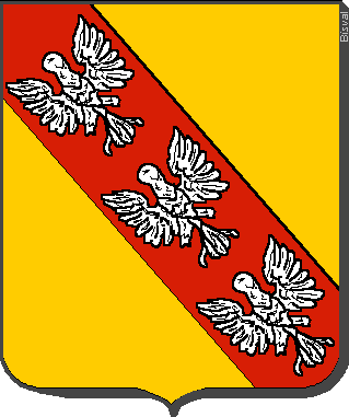
Symbolism[edit]
Heraldry[edit]

This section to be extended.
Strasbourg[edit]

Strasbourg's arms are the colours of the shield of the Bishop of Strasbourg (a band of red on a white field, also considered an inversion of the arms of the diocese) at the end of a revolt of the burghers during the Middle Ages who took their independence from the teachings of the Bishop. It retains its power over the surrounding area.
Flags[edit]
.svg)
.svg)
There is controversy around the recognition of the Alsacian flag. The authentic historical flag is the Rot-un-Wiss ; Red and White are commonly found on the coat of arms of Alsacian cities (Strasbourg, Mulhouse, Sélestat...)[22] and of many Swiss cites, especially in Basel's region. The German region Hesse uses a flag similar to the Rot-un-Wiss. As it underlines the Germanic roots of the region, it was replaced in 1949 by a new "Union jack-like" flag representing the union of the two déprtements. It has however no real historical relevance. It has been since replaced again by a slightly different one, also representing the two départements.[23] With the purpose of "Frenchizing" the region, the Rot-un-Wiss has not been recognized by Paris. Some overzealous statesmen have called it a Nazi invention - while its origins date back to the XIth century and the Red and White banner[24] of Gérard de Lorraine (aka. d'Alsace). The Rot-un-Wiss flag is still known as the real historical emblem of the region by most of the population and the departments' parliaments and has been widely used during protests against the creation of a new "super-region" gathering Champagne-Ardennes, Lorraine and Alsace, namely on Colmar's statue of liberty.[25]
Language[edit]

Although German dialects were spoken in Alsace for most of its history, the dominant language in Alsace today is French.
The traditional language of the région is Alsatian, an Alemannic dialect of Upper German spoken on both sides of the Rhine and closely related to Swiss German. Some Frankish dialects of West Central German are also spoken in "Alsace Bossue" and in the extreme north of Alsace. Neither Alsatian nor the Frankish dialects have any form of official status, as is customary for regional languages in France, although both are now recognized as languages of France and can be chosen as subjects in lycées.
Although Alsace has been part of France multiple times in the past, the region had no direct connection with the French state for several centuries. From the end of the Roman Empire (5th century) to the French annexation (17th century), Alsace was politically part of the Germanic world.
The towns of Alsace were the first to adopt German language as their official language, instead of Latin, during the Lutheran Reform. It was in Strasbourg that German was first used for the liturgy. It was also in Strasbourg that the first German Bible was published in 1466.
From the annexation of Alsace by France in the 17th century and the language policy of the French Revolution up to 1870, knowledge of French in Alsace increased considerably. With the education reforms of the 19th century, the middle classes began to speak and write French well. The French language never really managed, however, to win over the masses, the vast majority of whom continued to speak their German dialects and write in German (which we would now call "standard German").[citation needed]
Between 1870 and 1918, Alsace was annexed by the German Empire in the form of an imperial province or Reichsland, and the mandatory official language, especially in schools, became High German. French lost ground to such an extent that it has been estimated that only 2% of the population spoke French fluently and only 8% had some knowledge of it (Maugue, 1970).
After 1918, French was the only language used in schools, and particularly primary schools. After much argument and discussion and after many temporary measures, a memorandum was issued by Vice-Chancellor Pfister in 1927 and governed education in primary schools until 1939.
During a reannexation by Germany (1940–1945), High German was reinstated as the language of education. The population was forced to speak German and 'French' family names were Germanized. Following the Second World War, the 1927 regulation was not reinstated and the teaching of German in primary schools was suspended by a provisional rectorial decree, which was supposed to enable French to regain lost ground. The teaching of German became a major issue, however, as early as 1946. Following World War II, the French government pursued, in line with its traditional language policy, a campaign to suppress the use of German as part of a wider Francization campaign.
In 1951, Article 10 of the Deixonne Law (Loi Deixonne) on the teaching of local languages and dialects made provision for Breton, Basque, Catalan and old Provençal, but not for Corsican, Dutch (West Flemish) or Alsatian in Alsace and Moselle. However, in a Decree of 18 December 1952, supplemented by an Order of 19 December of the same year, optional teaching of the German language was introduced in elementary schools in Communes where the language of habitual use was the Alsatian dialect.
In 1972, the Inspector General of German, Georges Holderith, obtained authorization to reintroduce German into 33 intermediate classes on an experimental basis. This teaching of German, referred to as the Holderith Reform, was later extended to all pupils in the last two years of elementary school. This reform is still largely the basis of German teaching (but not Alsatian) in elementary schools today.
It was not until 9 June 1982, with the Circulaire sur la langue et la culture régionales en Alsace (Memorandum on regional language and culture in Alsace) issued by the Vice-Chancellor of the Académie Pierre Deyon, that the teaching of German in primary schools in Alsace really began to be given more official status. The Ministerial Memorandum of 21 June 1982, known as the Circulaire Savary, introduced financial support, over three years, for the teaching of regional languages in schools and universities. This memorandum was, however, implemented in a fairly lax manner.
Both Alsatian and Standard German were for a time banned from public life (including street and city names, official administration, and educational system). Though the ban has long been lifted and street signs today are often bilingual, Alsace-Lorraine is today very French in language and culture. Few young people speak Alsatian today, although there do still exist one or two enclaves in the Sundgau region where some older inhabitants cannot speak French, and where Alsatian is still used as the mother tongue. A related Alemannic German survives on the opposite bank of the Rhine, in Baden, and especially in Switzerland. However, while French is the major language of the region, the Alsatian dialect of French is heavily influenced by German and other languages such a Yiddish in phonology and vocabulary.
This situation has spurred a movement to preserve the Alsatian language, which is perceived as endangered, a situation paralleled in other régions of France, such as Brittany or Occitania. Alsatian is now taught in French high schools. Increasingly, French is the only language used at home and at work, whereas a growing number of people have a good knowledge of standard German as a foreign language learned in school.
The constitution of the Fifth Republic states that French alone is the official language of the Republic. However, Alsatian, along with other regional languages, are recognized by the French government in the official list of languages of France. A 1999 INSEE survey counted 548,000 adult speakers of Alsatian in France, making it the second most-spoken regional language in the country (after Occitan). Like all regional languages in France, however, the transmission of Alsatian is on the decline. While 39% of the adult population of Alsace speaks Alsatian, only one in four children speaks it, and only one in ten children uses it regularly.
In 1992, the French government signed the European Charter for Regional or Minority Languages. However visitors to Alsace can see indications of renewed political and cultural interest in the language – in Alsatian signs appearing in car-windows and on hoardings, and in new official bilingual street signs in Strasbourg and Mulhouse.
Architecture[edit]

The traditional habitat of the Alsatian lowland, like in other regions of Germany and Northern Europe, consists of houses constructed with walls in timber framing and cob and roofing in flat tiles. This type of construction is abundant in adjacent parts of Germany and can be seen in other areas of France, but their particular abundance in Alsace is owed to several reasons:
- The proximity to the Vosges where the wood can be found.
- During periods of war and bubonic plague, villages were often burned down, so to prevent the collapse of the upper floors, ground floors were built of stone and upper floors built in half-timberings to prevent the spread of fire.
- During most of the part of its history, a great part of Alsace was flooded by the Rhine every year. Half-timbered houses were easy to knock down and to move around during those times (a day was necessary to move it and a day to rebuild it in another place).
However, half-timbering was found to increase the risk of fire, which is why from the 19th century, it began to be rendered. In recent times, villagers started to paint the rendering white in accordance with Beaux-Arts movements. To discourage this, the region's authorities gave financial grants to the inhabitants to paint the rendering in various colors, in order to return to the original style and many inhabitants accepted (more for financial reasons than by firm belief).[citation needed]
Cuisine[edit]

Alsatian cuisine, somewhat based on Germanic culinary traditions, is marked by the use of pork in various forms. It is perhaps mostly known for the region's wines and beers. Traditional dishes include baeckeoffe, flammekueche, choucroute, and fleischnacka. Southern Alsace, also called the Sundgau, is characterized by carpe frite (that also exists in Yidish tradition).
Alimentation[edit]
The festivities of the year's end involve the production of a great variety of biscuits and small cakes called bredela as well as pain d'épices (gingerbread cakes) which are baked around Christmas time.
The gastronomic symbol of the région is undoubtedly the Choucroute, a local variety of Sauerkraut. The word Sauerkraut in Alsatian has the form sûrkrût, same as in other southwestern German dialects, and means "sour cabbage" as its Standard German equivalent. This word was included into the French language as choucroute. To make it, the cabbage is finely shredded, layered with salt and juniper and left to ferment in wooden barrels. Sauerkraut can be served with poultry, pork, sausage or even fish. Traditionally it is served with Strasbourg sausage or frankfurters, bacon, smoked pork or smoked Morteau or Montbéliard sausages, or a selection of other pork products. Served alongside are often roasted or steamed potatoes or dumplings.
Alsace is also well known for its foie gras made in the region since the 17th century. Additionally, Alsace is known for its fruit juices and mineral waters.
Wines[edit]

Alsace is an important wine-producing région. Vins d'Alsace (Alsace wines) are mostly white and display a strong Germanic influence. Alsace produces some of the world's most noted dry rieslings and is the only région in France to produce mostly varietal wines identified by the names of the grapes used (wine from Burgundy is also mainly varietal, but not normally identified as such), typically from grapes also used in Germany. The most notable example is Gewürztraminer.
Beers[edit]

Alsace is also the main beer-producing région of France, thanks primarily to breweries in and near Strasbourg. These include those of Fischer, Karlsbräu, Kronenbourg, and Heineken International. Hops are grown in Kochersberg and in northern Alsace. Schnapps is also traditionally made in Alsace, but it is in decline because home distillers are becoming less common and the consumption of traditional, strong, alcoholic beverages is decreasing.
Trivia[edit]

The stork is a main feature of Alsace and was the subject of many legends told to children. The bird practically disappeared around 1970, but re-population efforts are continuing. They are mostly found on roofs of houses, churches and other public buildings in Alsace.
The Easter Bunny was first mentioned in Georg Franck von Franckenau's De ovis paschalibus (About Easter Eggs) in 1682 referring to an Alsace tradition of an Easter Hare bringing Easter Eggs.
Economy[edit]
According to the Institut National de la Statistique et des Études Économiques (INSEE), Alsace had a gross domestic product of 44.3 billion euros in 2002. With a GDP per capita of €24,804, it was the second-place région of France, losing only to Île-de-France. 68% of its jobs are in the services; 25% are in industry, making Alsace one of France's most industrialised régions.
Alsace is a région of varied economic activity, including:
- viticulture (mostly along the Route des Vins d'Alsace between Marlenheim and Thann)
- hop harvesting and brewing (half of French beer is produced in Alsace, especially in the vicinity of Strasbourg, notably in Strasbourg-Cronenbourg, Schiltigheim and Obernai)
- forestry development
- automobile industry (Mulhouse and Molsheim, home town of Bugatti Automobiles)
- life sciences, as part of the trinational BioValley and
- tourism
- potassium chloride (until the late 20th century) and phosphate mining
Alsace has many international ties and 35% of firms are foreign companies (notably German, Swiss, American, Japanese, and Scandinavian).
Tourism[edit]
Having been early and always densely populated, Alsace is famous for its high number of picturesque villages, churches and castles and for the various beauties of its three main towns, in spite of severe destructions suffered throughout five centuries of wars between France and Germany.
Alsace is furthermore famous for its vineyards (especially along the 170 km of the Route des Vins d'Alsace from Marlenheim to Thann) and the Vosges mountains with their thick and green forests and picturesque lakes.


- Old towns of Strasbourg, Colmar, Sélestat, Guebwiller, Saverne, Obernai, Thann
- Smaller cities and villages: Molsheim, Rosheim, Riquewihr, Ribeauvillé, Kaysersberg, Wissembourg, Neuwiller-lès-Saverne, Marmoutier, Rouffach, Soultz-Haut-Rhin, Bergheim, Hunspach, Seebach, Turckheim, Eguisheim, Neuf-Brisach, Ferrette, Niedermorschwihr and the gardens of the blue house in Uttenhoffen[26]
- Churches (as main sights in otherwise less remarkable places): Thann, Andlau, Murbach, Ebersmunster, Niederhaslach, Sigolsheim, Lautenbach, Epfig, Altorf, Ottmarsheim, Domfessel, Niederhaslach, Marmoutier and the fortified church at Hunawihr
- Château du Haut-Kœnigsbourg
- Other castles: Ortenbourg and Ramstein (above Sélestat), Hohlandsbourg, Fleckenstein, Haut-Barr (above Saverne), Saint-Ulrich (above Ribeauvillé), Lichtenberg, Wangenbourg, the three Castles of Eguisheim, Pflixbourg, Wasigenstein, Andlau, Grand Geroldseck, Wasenbourg
- Musée de l'automobile de Mulhouse
- Cité du train museum in Mulhouse
- The EDF museum in Mulhouse
- Ungersheim's "écomusée" (open air museum) and "Bioscope" (leisure park about the environment, closed since September 2012)
- Musée historique in Haguenau, largest museum in Bas-Rhin outside Strasbourg
- Bibliothèque humaniste in Sélestat, one of the oldest public libraries in the world
- Christmas markets in Kaysersberg, Strasbourg, Mulhouse and Colmar
- Departmental Centre of the History of Families (CDHF) in Guebwiller
- The Maginot Line: Ouvrage Schoenenbourg
- Mount Ste Odile
- Route des Vins d'Alsace (Alsace Wine Route)
- Mémorial d'Alsace-Lorraine in Schirmeck
- Natzweiler-Struthof, the only German concentration camp on French territory during WWII
- Famous mountains: Massif du Donon, Grand Ballon, Petit Ballon, Ballon d'Alsace, Hohneck, Hartmannswillerkopf
- National park: Parc naturel des Vosges du Nord
- Regional park: Parc naturel régional des Ballons des Vosges (south of the Vosges)
Transportation[edit]
Roads[edit]

Most major car journeys are made on the A35 autoroute, which links Saint-Louis on the Swiss border to Lauterbourg on the German border.
The A4 toll road (towards Paris) begins 20 km northwest of Strasbourg and the A36 toll road towards Lyon, begins 10 km west from Mulhouse.
Spaghetti-junctions (built in the 1970s and 1980s) are prominent in the comprehensive system of motorways in Alsace, especially in the outlying areas of Strasbourg and Mulhouse. These cause a major buildup of traffic and are the main sources of pollution in the towns, notably in Strasbourg where the motorway traffic of the A35 was 170,000 per day in 2002.
At present, plans are being considered for building a new dual carriageway west of Strasbourg, which would reduce the buildup of traffic in that area by picking up north- and southbound vehicles and getting rid of the buildup outside Strasbourg. The line plans to link up the interchange of Hœrdt to the north of Strasbourg, with Innenheim in the southwest. The opening is envisaged at the end of 2011, with an average usage of 41,000 vehicles a day. Estimates of the French Works Commissioner however, raised some doubts over the interest of such a project, since it would pick up only about 10% of the traffic of the A35 at Strasbourg. Paradoxically, this reversed the situation of the 1950s. At that time, the French trunk road left of the Rhine not been built, so that traffic would cross into Germany to use the Karlsruhe-Basel Autobahn.
To add to the buildup of traffic, the neighbouring German state of Baden-Württemberg has imposed a tax on heavy-goods vehicles using their Autobahnen. Thus, a part of the HGVs travelling from north Germany to Switzerland or southern Alsace bypasses the A5 on the Alsace-Baden-Württemberg border and uses the untolled, French A35 instead.
The French Assemblée Nationale allowed a tax on HGVs using the alsatian road network in 2005. It must be applicated since beginning 2008.
Trains[edit]

TER Alsace is the rail network serving Alsace. Its network is articulated around the city of Strasbourg. It is one of the most developed rail networks in France, financially sustained partly by the French railroad SNCF, and partly by the région Alsace.
Because the Vosges are surmountable only by the Col de Saverne and the Belfort Gap, it has been suggested that Alsace needs to open up and get closer to France in terms of its rail links.
The TGV Est (Paris – Strasbourg) had its first phase brought into service in June 2007, bringing down the Strasbourg-Paris trip from 4 hours to 2 hours 20 minutes. Work on its second phase in 2010, which will further bring down this time to 1hour 50 minutes, started in 2010. Further plans include:
- the TGV Rhin-Rhône or a Dijon-Mulhouse line (to start in construction in 2006, with anticipated completion in 2011)
- an interconnection with the German InterCityExpress, as far as Kehl and/or Ottmarsheim
- a tram-train system in Mulhouse (May 2006), then Strasbourg (2011)
However, the abandoned Maurice-Lemaire tunnel towards Saint-Dié-des-Vosges was rebuilt as a toll road.
Rivers[edit]
Port traffic of Alsace exceeds 15 million tonnes, of which about three-quarters is centred on Strasbourg, which is the second busiest French fluvial harbour. The enlargement plan of the Rhine-Rhône channel, intended to link up the Mediterranean Sea and Central Europe (Rhine, Danube, North Sea and Baltic Sea) was abandoned in 1998 for reasons of expense and land erosion, notably in the Doubs valley.
Air traffic[edit]
There are two international airports in Alsace:
- the international airport of Strasbourg in Entzheim
- the international EuroAirport Basel-Mulhouse-Freiburg, which is the seventh largest French airport in terms of traffic
Strasbourg is also two hours away by road from one of the largest European airports, Frankfurt Main, and 2 hour 30 minutes from Charles de Gaulle Airport through the direct TGV service, stopping in Terminal 2.
Cycling network[edit]
Crossed by three EuroVelo routes
- the EuroVelo 5 (Via Francigena from London to Rome/Brindisi),
- the EuroVelo 6 (Véloroute des fleuves from Nantes to Budapest (H)) and
- the EuroVelo 15 (Véloroute Rhin / Rhine cycle route from Andermatt (CH) to Rotterdam (NL)).
Alsace is the most well equipped region of France with 2 000 kilometers cycle routes. The network is of a very good standard and well signposted. All the tow pathes of the canals in Alsace (canal des houillères de la Sarre, canal de la Marne au Rhin, canal de la Bruche, canal du Rhône au Rhin) are tarred.
Alsatians[edit]

- Paul Émile Appell
- Jean Arp
- Frédéric Bartholdi
- Max Bense
- Hans Bethe
- Karl Brandt
- Sebastian Brant
- David Emil Bronnert
- Henry Bronnert
- Martin Bucer
- Theodore Deck
- Mireille Delunsch
- Artur Dinter
- Gustave Doré
- Alfred Dreyfus
- Mathieu Dreyfus
- Charles de Foucauld
- Charles Friedel
- Thierry Omeyer
- Georges Friedel
- Charles Frédéric Gerhardt
- Charles Frédéric Girard
- Gottfried von Straßburg
- Albert Kahn
- Johann Geiler von Kaisersberg
- Xavier Haegy
- Alfred Kastler
- François-Christophe Kellermann
- Jean-Baptiste Kléber
- Katia and Maurice Krafft
- Johann Heinrich Lambert
- Pope Saint Leo IX
- Bernard Lauth
- Julius Leber
- Jean-Marie Lehn
- Sébastien Loeb
- Philip James de Loutherbourg
- Marcel Marceau
- Sam Marx, father of the Marx Brothers
- Otto Meissner
- Hans-Otto Meissner
- Johannes Mentelin
- Paul Meyer
- Germain Muller
- Yvan Muller
- Charles Münch
- Viktor Nessler
- Jean-Frédéric Oberlin
- François-Joseph Offenstein
- Beatus Rhenanus
- Claude Rich
- Jean Sandherr
- The Schlumberger brothers
- Morgan Schneiderlin
- Martin Schongauer
- Albert Schweitzer
- Pierre Seel
- Charles Spindler
- Philipp Jakob Spener
- François Spoerry
- Sebastian Stoskopff
- Jacob Sturm von Sturmeck
- Marie Tussaud
- Tomi Ungerer
- Claude Vigée
- Thomas Voeckler
- Jean-Georges Vongerichten
- Émile Waldteufel
- Jean-Jacques Waltz aka Hansi
- Arsène Wenger
- Alfred Werner
- Eugene Wilhelm
- André Wilms
- Bob Wollek
- Charles-Adolphe Wurtz
- William Wyler
Major communities[edit]
German original names in brackets if French names are different
- Bischheim
- Colmar (Kolmar)
- Guebwiller (Gebweiler)
- Haguenau (Hagenau)
- Illkirch-Graffenstaden (Illkirch-Grafenstaden)
- Illzach
- Lingolsheim
- Mulhouse (Mülhausen)
- Saint-Louis (St. Ludwig)
- Saverne (Zabern)
- Schiltigheim
- Sélestat (Schlettstadt)
- Strasbourg (Straßburg)
- Wittenheim
Sister provinces[edit]
There is an accord de coopération internationale between Alsace and the following regions:[27]
 Gyeongsangbuk-do, South Korea
 Lower Silesia, Poland
 Upper Austria, Austria
 Quebec, Canada
 Jiangsu, China
 Moscow, Russia
 Vest, Romania
See also[edit]
- German place names (Alsace)
- History of Jews in Alsace
- Musée alsacien (Strasbourg)
- Route Romane d'Alsace
- Castroville, Texas
Footnotes[edit]
- ^ "Insee – Résultats du recensement de la population – 2006 – Alsace" (in French). Recensement.insee.fr. Retrieved 16 April 2010.
- ^ INSEE. "Produits intérieurs bruts régionaux et valeurs ajoutées régionales de 1990 à 2012". Retrieved 4 March 2014.
- ^ [1] "L'alsacien, deuxième langue régionale de France" Insee, Chiffres pour l'Alsace no. 12, December 2002
- ^ http://www.olcalsace.org/fr/observer-et-veiller/le-dialecte-en-chiffres
- ^ Bostock, John Knight; Kenneth Charles King; D. R. McLintock (1976). Kenneth Charles King, D. R. McLintock, ed. A Handbook on Old High German Literature (2nd ed.). Oxford: Clarendon Press. p. 20. ISBN 0-19-815392-9.
- ^ Roland Kaltenbach: Le guide de l’Alsace, La Manufacture 1992, ISBN 2-7377-0308-5, page 36
- ^ Sherman, Irwin W. (2006). The power of plagues. Wiley-Blackwell. p. 74. ISBN 1-55581-356-9.
- ^ Veve, Thomas Dwight (1992). The Duke of Wellington and the British army of occupation in France, 1815–1818, pp. 20–21. Greenwood Press, Westport, Connecticut, United States.
- ^ http://members.cox.net/smithgen/sources/ships/ships18201850notes.htm#sully1838match
- ^ [2][dead link]
- ^ Vicki Caron, "Alsace," in Richard S. Levy, ed., Antisemitism: A historical Encyclopedia of prejudice and persecution (2005) 1:13-16
- ^ Alsace-Lorraine since 1870 (full text) by Barry Cerf (1919) at the Internet Archive
- ^ REMAKING THE MAP OF EUROPE by Jean Finot, The New York Times, May 30, 1915
- ^ In fact, France ceded more than nine-tenths of Alsace and one-fourth of Lorraine as stipulated in the treaty of Frankfurt. De jure, that wasn't an annexation any more.
- ^ Have a look at this archive video.
- ^ However, propaganda for elections was allowed to go with a German translation from 1919 to 2008.
- ^ Stéphane Courtois, Mark Kramer. Livre noir du Communisme: crimes, terreur, répression. Harvard University Press, 1999. p.323. ISBN 0-674-07608-7
- ^ Note: the commune of Strasbourg is not inside the arrondissement of Strasbourg-Campagne but it is nonetheless the seat of the Strasbourg-Campagne sous-préfecture buildings and administration.
- ^ INSEE. "Fichier Données harmonisées des recensements de la population de 1968 à 2011" (in French). Retrieved 2014-10-25.
- ^ INSEE. "IMG1B – Les immigrés par sexe, âge et pays de naissance" (in French). Retrieved 2014-10-25.
- ^ INSEE. "D_FD_IMG2 – Base France par départements – Lieux de naissance à l'étranger selon la nationalité" (in French). Retrieved 26 June 2013.
- ^ http://www.unserland.org/dossiers/breve-histoire-dun-drapeau-alsacien/
- ^ fr:Drapeau de l'Alsace#mediaviewer/File:Flag of Alsace.svg
- ^ http://www.genealogie-bisval.net/Images/Lorraine.gif
- ^ http://france3-regions.francetvinfo.fr/alsace/2014/11/16/colmar-une-statu-de-la-liberte-en-rot-und-wiss-593102.html
- ^ "Jardins de la ferme bleue – SehenswĂźrdigkeiten in Uttenhoffen, ElsaĂ&#x;". beLocal.de. 23 November 2011. Retrieved 30 March 2012.
- ^ Les Accords de coopération entre l’Alsace et...[dead link] (French)
Bibliography[edit]
- Assall, Paul. Juden im Elsass. Zürich: Rio Verlag. ISBN 3-907668-00-6.
- Das Elsass: Ein literarischer Reisebegleiter. Frankfurt a. M.: Insel Verlag, 2001. ISBN 3-458-34446-2.
- Erbe, Michael (Hrsg.) Das Elsass: Historische Landschaft im Wandel der Zeiten. Stuttgart: Kohlhammer, 2002. ISBN 3-17-015771-X.
- Faber, Gustav. Elsass. München: Artemis-Cicerone Kunst- und Reiseführer, 1989.
- Fischer, Christopher J. Alsace to the Alsatians? Visions and Divisions of Alsatian Regionalism, 1870–1939 (Berghahn Books, 2010).
- Gerson, Daniel. Die Kehrseite der Emanzipation in Frankreich: Judenfeindschaft im Elsass 1778 bis 1848. Essen: Klartext, 2006. ISBN 3-89861-408-5.
- Haeberlin, Marc. Elsass, meine große Liebe. Orselina, La Tavola 2004. ISBN 3-909909-08-6
− Rezension über das „Schlaraffenland“ Elsass - Herden, Ralf Bernd. Straßburg Belagerung 1870. Norderstedt: BoD, 2007, ISBN 978-3-8334-5147-8.
- Mehling, Marianne (Hrsg.) Knaurs Kulturführer in Farbe Elsaß. München: Droemer Knaur, 1984.
- Putnam, Ruth. Alsace and Lorraine: From Cæsar to Kaiser, 58 B.C.–1871 A.D. New York: 1915.
- Schreiber, Hermann. Das Elsaß und seine Geschichte, eine Kulturlandschaft im Spannungsfeld zweier Völker. Augsburg: Weltbild, 1996.
- Schwengler, Bernard. Le Syndrome Alsacien: d'Letschte? Strasbourg: Éditions Oberlin, 1989. ISBN 2-85369-096-2.
- Ungerer, Tomi. Elsass. Das offene Herz Europas. Straßburg: Édition La Nuée Bleue, 2004. ISBN 2-7165-0618-3.
- Ungerer, Tomi, Danièle Brison, and Tony Schneider. Die elsässische Küche. 60 Rezepte aus der Weinstube L'Arsenal. Straßburg: Édition DNA, 1994. ISBN 2-7165-0341-9.
- Vogler, Bernard and Hermann Lersch. Das Elsass. Morstadt: Éditions Ouest-France, 2000. ISBN 3-88571-260-1.
External links[edit]
| Wikimedia Commons has media related to Alsace. |
- Official website of the Alsace regional council
- Alsace : at the heart of Europe – Official French website (in English)
- Tourism-Alsace.com Info from the Alsace Tourism Board
- Rhine Online – life in southern Alsace and neighbouring Basel and Baden Wuerrtemburg
- Alsatourisme Tourism in Alsace (French)
- Alsace at DMOZ
- Statistics and figures on Alsace on the website of the INSEE (French)
- Alsace.net: Directory of Alsatian Websites (French)
- "Museums of Alsace" (French)
- Churches and chapels of Alsace (pictures only) (French)
- Medieval castles of Alsace (pictures only) (French)
- "Alsatian language Wiki" (Elsassisch)
- "Organs of Alsace" (French)
- The Alsatian Library of Mutual Credit (French)
- The Alsatian Artists (French)
|
||||||||||||||||||

|
||||||||

Coordinates: 48°30′N 7°30′E / 48.500°N 7.500°E

